History
The District is a political subdivision of the State of Texas, located approximately 16 miles south of the central business district of the City of Houston, Texas. The District lies entirely within the extraterritorial jurisdiction and limited purpose jurisdiction of the City of Manvel, Texas. The District is a municipal utility district created by an order of the TCEQ effective January 23, 2007. The District operates in accordance with Chapters 49 and 54 of the Texas Water Code, as amended, Chapter 8429 of the Texas Special District Local Laws Code, and other statutes of Texas applicable to municipal utility districts. The District consists of approximately 476.171 total acres.
The District is one of the two municipal utility districts (the District and Brazoria County Municipal Utility District No. 40) that make up the approximate 1,000-acre, master-planned community known as Pomona. To date, development and construction activity in Pomona has occurred primarily within the District, although the initial phase of development of lands within Brazoria County Municipal Utility District No. 40 has recently begun and currently includes construction of the following: two detention ponds, one lift station, and two residential sections to be developed as approximately 152 single-family lots.
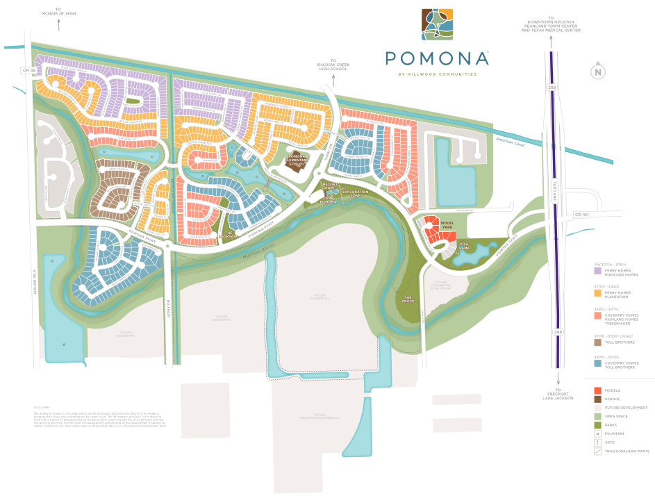
To date, approximately 176.05 acres within the District have been developed as the residential subdivision of Pomona, Sections 1–8 (598 lots). As of June 30, 2018, the District included approximately 333 completed homes (approximately 274 occupied, 52 unoccupied, and 7 model homes); approximately 80 homes under construction; and approximately 185 vacant developed lots. The remaining land within the District includes the following: approximately 2.28 acres for Water Supply Plant No. 1; approximately 7.21 acres for a wastewater treatment plant serving Pomona; approximately 6.20 acres for Brazoria County Annex; approximately 12.95 acres for Pomona Elementary School; approximately 149.11 undevelopable acres consisting of easements, rights-of-way, and greenbelts; and approximately 122.37 undeveloped but developable acres.
District Map
Election Information
Board of Directors Elections
The next directors election is scheduled for Saturday, May 7, 2022. The District will establish the polling place(s) for the election, which will be provided in the Notice of Election.
Applications for a place on the ballot may be filed from January 19, 2022, to 5:00 p.m. local time on February 18, 2022. For information about the requirements for filing for candidacy for a position on the Board, please visit the Texas Secretary of State’s candidate website, at https://www.sos.state.tx.us/elections/candidates/index.shtml.
Elecciones de la Junta Directiva
La próxima elección de directores está programada para el sábado 7 de mayo de 2022; El Distrito establecerá el(los) lugar(es) para la elección, los cuales serán provistos en el Aviso de Elección.
Las solicitudes para un lugar en la boleta de votación pueden presentarse desde el 19 de enero de 2022 hasta las 5:00 p.m. hora local del 18 de febrero de 2022. Para obtener información acerca de los requisitos para presentar la candidatura para una posición en la Junta, sírvase visitar ele sitio web del candidato del Secretario de Estado de Texas en https://www.sos.state.tx.us/elections/candidates/index.shtml.
Caùc Cuoäc Baàu Cöû Ban Giaùm Ñoác
Cuoäc baàu cöû caùc giaùm ñoác tieáp theo döï kieán ñöôïc toå chöùc vaøo thöù Baûy, 7 thaùng Naêm, 2022. Cô Quan seõ thieát laäp (caùc) ñòa ñieåm boû phieáu cho cuoäc baàu cöû, vaø thoâng tin veà ñòa ñieåm boû phieáu seõ coù trong Thoâng Baùo Baàu Cöû.
Thôøi gian noäp ñôn xin ghi teân treân laù phieáu laø töø ngaøy 19 thaùng Moät, 2022 ñeán 5 giôø chieàu giôø ñòa phöông ngaøy 18 thaùng Hai, 2022. Ñeå bieát theâm thoâng tin veà caùc yeâu caàu noäp ñôn tranh cöû cho moät ví trí cuûa Ban, vui loøng gheù thaêm website öùng cöû vieân cuûa Toång Tröôûng Tieåu Bang Texas taïi https://www.sos.state.tx.us/elections/candidates/index.shtml.
董事會選舉
下一次董事選舉定於2022年5月7日(週六)舉行。本區將為選舉設立投票所,具體詳見選舉通告.
提交參選申請的期限為2022年1月19日至2022年2月18日當地時間下午5:00。如需了解申請董事會席位候選資格的要求,請瀏覽Texas州州務卿候選人網站:https://www.sos.state.tx.us/elections/candidates/index.shtml。

